


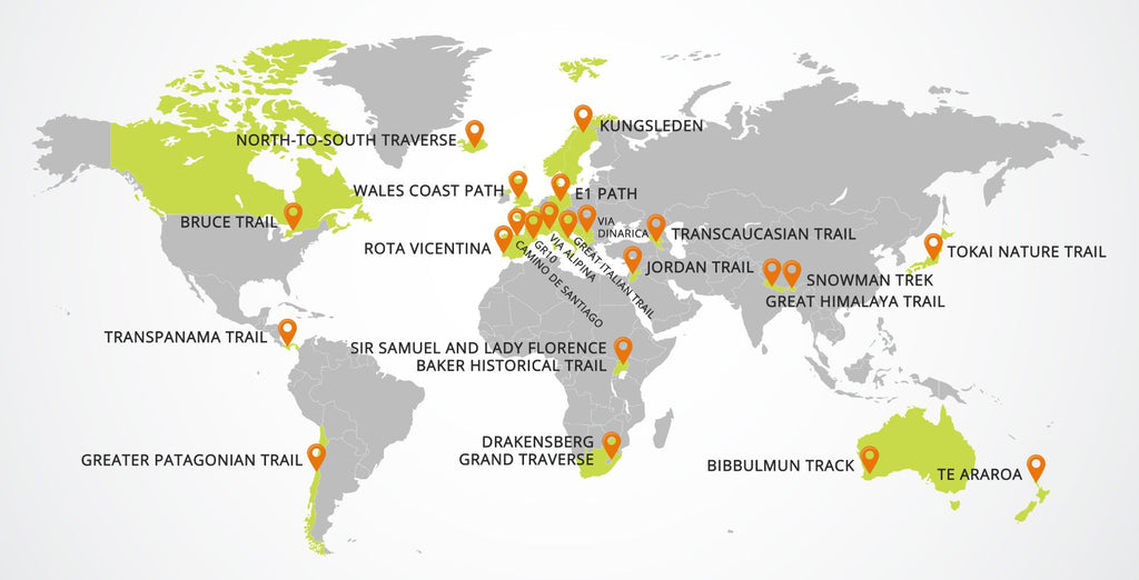
There are dozens of long-distance trails throughout the world waiting for you to discover. We profile 22 of these hidden gems in epic locations such as Bhutan and Argentina. All trails appearing on this are at least 200 miles long.
Europe
1. E1 European Long-Distance Path
The E1 European Long-Distance Path - abbreviated as E1 Path - travels through seven European countries.
- Countries: Norway, Finland, Sweden, Denmark, Germany, Switzerland, and Italy
- Distance: 4,960 miles (7,980 km)
- Time to complete: up to 12 months
- Elevation change: Unknown
- Best time to visit: May to September
The E1 is one of 12 European long distance walking paths that is maintained by the European Ramblers Association. The path is relatively new - it was constructed in 2011 and is continuing to be expanded. In 2018, the southern terminus was extended to Sicily in Italy.
Most people hike the path in sections. To date, there are no documented full-length thru-hikes. Both the European Ramblers Association and the Hiking Europe website contain additional details about the trail.
 CC BY-SA 2.0 | Alain Rouiller
2. GR10
A strenuous hike along the Pyrenees that links the Atlantic Ocean to the Mediterranean Sea.
- Countries: France
- Distance: 866km (538mi)
- Time to complete: 2 months
- Elevation change: 48,000m (157,000ft) elevation gain
- Best time to visit: May to June or August to September
Starting at the Atlantic ocean, the GR10 follows the backbone of the Pyrenees mountain range along the French-Spanish border to the Mediterranean Sea. Hikers will experience everything from lush green meadows, dense forests and snow-covered mountain peaks.
Although the trail is well marked, it is wild and remote. Only experienced hikers should consider taking on the steep climbs of this rugged, mountainous terrain. Mountain IQ is an excellent resource for information on the GR10.

3. North-To-South Traverse
Pick your path as you travel from one end of Iceland to the other.
- Countries: Iceland
- Distance: Approximately 550 km (340 mi)
- Time to complete: 3 to 4 weeks
- Elevation change: Unknown
- Best time to visit: June to July
Iceland is known for its gorgeous, varied landscape that includes volcanoes, hot springs, deserts, lush green valleys, and snowy mountaintops. The North to South traverse is not a dedicated hiking trail but a cross country trek through a loose collection of primitive roads, unmarked paths, and hiking trails.
Part of this north to south trek takes you through the Fjallabak Nature Reserve and the Laugavegur trail, which is considered to be among the most beautiful hiking trails in the world. The route is mostly flat, but be prepared for high winds and unpredictable weather in Iceland's mostly treeless landscape.
You can learn more about the North-South traverse from online trail journals by those who have completed this trek (e.g. Tucker Prescott or Jonathan Ley).

4. Grand Italian Trail (Sentiero Italia)
- Countries: Italy
- Distance: Approximately 6166 km (3831 mi)
- Time to complete: up to 12 months
- Elevation change: Unknown
- Best time to visit: March to November
Want to see Italy on foot? Then check out the national trail of Italy, the Grand Italian Trail (Sentiero Italia). It links several smaller footpaths allowing a hiker to cross the Alps while walking the entire length of the country from Trieste to Sardinia. You'll cross snow-capped mountains, visit ancient ruins and travel through vineyards and valleys.
Some of the trails are marked, much of it is not, and you'll need an existing GPS track to keep on the right path. If 6,000K is too long for a single thru-hike, not a problem. The Grand Italian Trail is divided into 368 sections so you can hike it one piece at a time.
You can find a map and GPS data for the Grand Italian Trail at Traildino.

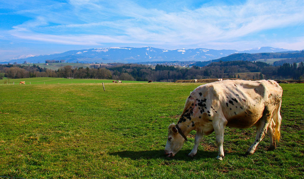
5. Via Alpina (red trail)
Immerse yourself into the Alpine lifestyle by hiking along the backbone of the Alps.
- Countries: Italy, Slovenia, Austria, Germany, Liechtenstein, Switzerland, France and Monaco.
- Distance: 2600km (1615mi)
- Time to complete: 4 to 5 months
- Elevation change: 138km (86 miles)
- Best time to visit: June till October
Created by both private and public groups in eight alpine countries, the Via Alpina is a network of five international long-distance hiking trails. The longest trail is the Red trail (2600km) which starts in Trieste, Italy and goes all the way to Monaco. The trail network was chosen not for its difficulty, but its cultural and historical significance.
You won't need ice axes, ropes or crampons to travel this route through the Alps, just time and a willingness to be immersed in the Alpine lifestyle. It's a welcoming trail with ample small towns eager to provide a warm bed and hot food to weary travelers.
Visit the Via Alpina website trip planning and trail information.
 CC BY-SA 4.0 | Attila Gaspar
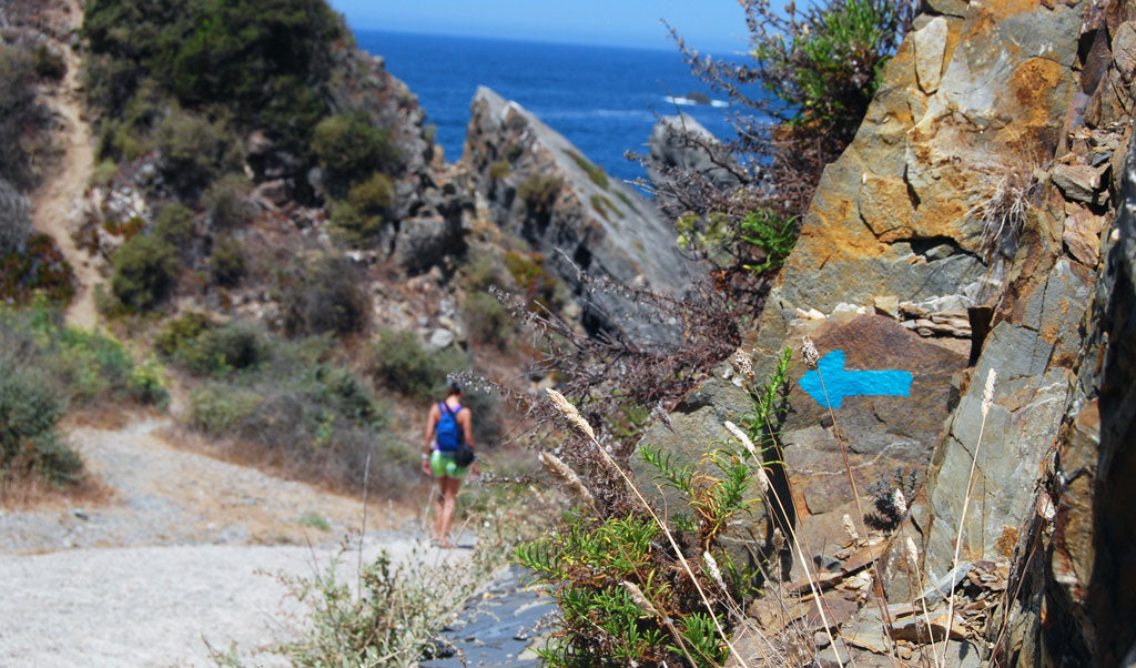
6. Rota Vicentina
Walk the historical footpaths and dirt roads used by travelers and locals for centuries.
- Countries: Portugal
- Distance: 450km (280mi)
- Time to complete: up to one month
- Elevation change: Unknown
- Best time to visit: September to June
The Rota Vicentina is a network of trails in southwest Portugal that extends from Santiago do Cacém to the Cape of São Vicente. It is comprised of two main long-distance trails (Historical Way and Fisherman's Trail) and eight circular routes for those who can't spend as much time on the trail.
Using existing trails and dirt roads, the Rota Vicentina takes you into the mountainous forest, along the coast and through the small villages that dot the region. Besides the local cuisine, the highlight of the Rota Vicentina is the coastal cliffs that provide stunning views of the Atlantic ocean. These cliffs are found on the FIsherman’s Trail section which follows the historic trails used by fisherman who traveled daily from their villages to the ocean to fish.
Visit the Rota Vicentina website for more information.
 CC BY 2.0 | Cláudio Franco
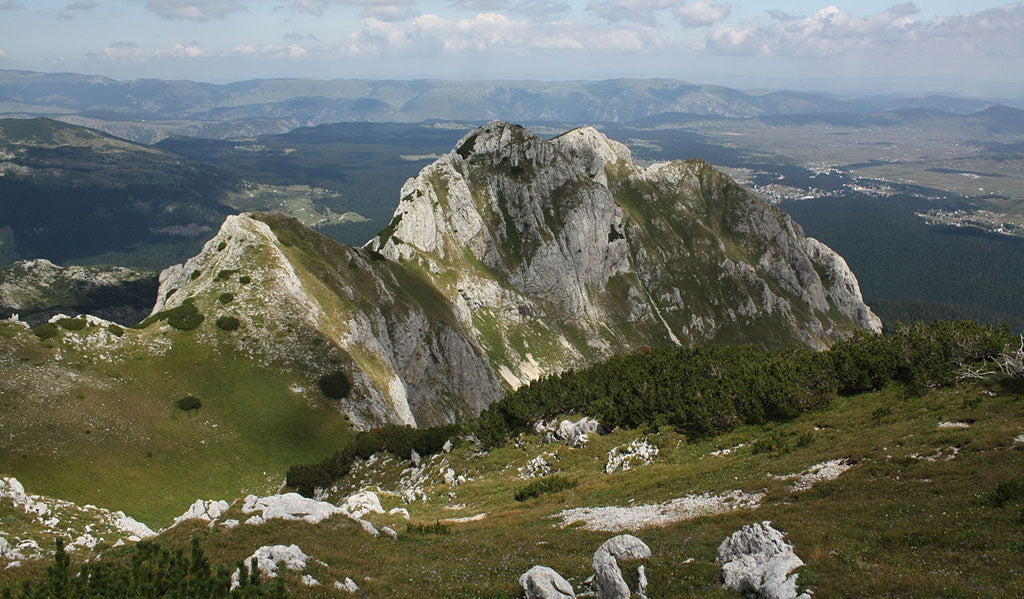
7. Via Dinarica
Trek the Western Balkans in a trail deemed one of the best in Europe by National Geographic.
- Countries: Slovenia, Croatia, Serbia, Bosnia and Herzegovina, Montenegro, Kosovo, and Albania
- Distance: 2,000km (1,054mi)
- Time to complete: 3 to 4 months
- Elevation change: 51,815m
- Best time to visit: June to September
Decades of conflict made the Balkans a problematic region to explore, but this isolation is quickly disappearing. The Balkans is quickly becoming a hub for eco-tourism thanks in part to the Via Dinarica, deemed to be one of the best hiking trails in Europe.
The primary path is the 1260km White trail, which is marked and has been thru-hiked numerous times since the idea for the trail was first conceived in 2010. The trail connects remote villages along the sharp peaks of the Dinaric Alps and Shar mountain ranges and follows former military routes, ancient trading routes, and shepherding paths.
The Via Dinarica website has a lot of information about the trail, places to stay and things to say when on the trail.
 CC BY-SA 3.0 | Wikimedia Commons (Mercy)
8. Camino De Santiago
Take a spiritual journey following the path the pilgrims walked to the shrine of Saint James.
- Countries: France, Spain, Portugal depending on the route
- Distance: Varies by route, the Camino Frances is 780km (500 miles)
- Time to complete: 3 weeks
- Elevation change: Unknown
- Best time to visit: April through September
The Camino De Santiago, known as the Way of Saint James, was one of the essential pilgrimages for Christians in the Middle Ages. The route ends at the cathedral of Santiago de Compostela where it is believed that the remains of Saint James are buried. The journey itself is made of several smaller pilgrimage routes all of which end at Santiago.
The most popular course is Camino Frances, which starts at Biarritz, France and travels 500 miles to Santiago, Spain. The route is relatively flat with people walking up to 18km to 25km per day.
The reason why people walk the Camino De Santiago varies, but many use it as a spiritual journey to fellowship with other pilgrims and stop at the many churches along the route. People use bikes, horses and even donkeys to travel the path.
There are several good books about the pilgrimage, including the popular Pilgrim's Guide from John Brierley.
 CC BY-SA 2.0 | Flickr (jmgarzo)
9. Kungsleden
Kungsleden, also known as the King's Trail, is Sweden's longest hiking trail.
- Countries: Sweden
- Distance: 440 km (270 mi) and three to four weeks
- Time to complete: 3 to 4 weeks
- Elevation change: minimum 2500m
- Best time to visit: June to September
Kungsleden is Sweden's longest hiking trail which welcomes hikers in the summer and skiers in the winter. First used in 1928 by the Swedish Tourist Association, the trail connects Abisko in the north and Hemavan in the south. The well-marked route takes you through the scenic Swedish Lapland mountains which include high alpine peaks, old-growth coniferous forests, and lakes, lots of them. It also passes through the Vindelfjällen Nature Reserve, one of the largest protected areas in Europe.
There are huts along the route, about a day apart, that are available without reservation for a small fee. The accommodations are simple - there are bunks and a place to cook food, but there is no electricity or running water. Some huts even sell food and other supplies.
Visit the Swedish Lapland website, the Swedish Tourist Association or Mountain IQ for more information.
 CC BY-SA 2.0 | Anders Rosqvist
10. Wales Coast Path
The world's first footpath that follows the entire coastline of a country.
- Countries: Wales
- Distance: 1,440km (870mi) and two to three months
- Time to complete: 2 to 3 months
- Elevation change: Unknown
- Best time to visit: April to September
Developed by the Welsh government along with other local authorities and national parks, the Welsh Coastal path opened in 2012. It begins at the city of Chester in the north and ends at the town of Chepstow in the south. Approximately 20% of the trail follows local roads away from the coast due to landowners who won't allow the path to cross their coastal property.
Most people hike the path in sections, taking time to savor the stunning ocean views, impressive cliffs, and historical sites. Unlike most trails where you encounter woodland animals, the Wales Coast Path allows you to experience the unique flora and fauna found in coastal locations such as beaches, dunes, estuaries, and salt marshes.
Details on the Wales Coast Path can be found on the trail's official website.
 CC BY 2.0 | David Evans
Asia
11. Jordan Trail
Learn about the culture and history of Jordan as you walk across the country.
- Countries: Jordan
- Distance: 650 km (400 mi)
- Time to complete: 4 to 6 weeks
- Elevation change: Unknown
- Best time to visit: February to April
People have been traveling Jordan by foot even before the first centuries B.C when people came to the country for commerce and trade. Now, these same roads are home to the Joran Trail which traverses 52 towns and villages as it winds its way from Um Qais in the North to the Aqaba in the south.
The Jordan trail was first conceived in the 1990s, but it wasn't until the Jordan Trail Association was formed in 1995 that the path was developed in earnest. Now it is being heralded as one of the best tourist destinations by National Geographic and others. The Jordan Trail Association website is the definitive source for trail maps, hiking guides, and current reroutes.
 CC BY-SA 3.0 | Wikimedia Commons (hikinginjordan)
12. Tokai Nature Trail
Japan's first long-distance trail winds leisurely from Tokyo to Osaka.
- Countries: Japan
- Distance: 1050km (652mi)
- Time to complete: 6 to 8 weeks
- Elevation change: 38,000m
- Best time to visit: April to June
More a nature walk than a remote wilderness hiking trail, the Tokai Nature Trail connects Tokyo's Meiji no Mori Takao Quasi-National Park with the Meiji no Mori Mino Quasi-National Park in Osaka. The trail climbs the gentle slopes of the Hokusetu Mountain Range and passes through cultural and historical sites.
The trail, suitable for seasoned hikers as well as families, was deliberately chosen to take people away from highly-traveled tourist locations and bring them into the heart of Japan. Check out the Tokai Walk website and Nomadic Tom’s Rough Guide for further details.

13. Snowman Trek
One of the toughest treks in the Himalayas crossing 11 high passes in one of the highest mountain ranges in the world.
- Countries: Bhutan
- Distance: 200 miles
- Time to complete: 4 weeks
- Elevation change: 48,000 feet elevation gain
- Best time to visit: May and Late September to October
Get a taste of Everest and the Himalayan mountains on this 200-mile hike through the country of Bhutan. The trek follows the backbone of the Himalayas along the northern border with Tibet. The trail climbs to 5000 meters providing scenic views of the surrounding mountains and glaciers.
Not for the faint of heart, most thru-hikers make the traverse in a group as part of a professionally guided tour. The best way to find out more about the Snowman Trek is to visit guide websites which have itineraries, tour prices and more.
 CC BY-SA 3.0 | Thomas Fuhrmann
14. Transcaucasian Trail
The Transcaucasian Trail is early in its development eventually will provide a breath-taking hike across the Caucasus mountain range in Eurasia.
- Countries: Georgia, Armenia, and Azerbaijan.
- Distance: 3000km (1864mi proposed)
- Time to complete: 4 months
- Elevation change: Unknown
- Best time to visit: June to September
Still under development, the Transcaucasian Trail will be 3000km (1864 miles) in length when it is finally completed. The trail will follow the Greater and Lesser Caucasus mountains in Georgia, Armenia, and Azerbaijan.
The motivation to create the path is dual in purpose - to help conserve land and showcase the natural beauty of the region. It will connect both existing and future national parks and will help to unify the sometimes tumultuous region.
To get a taste of the proposed trial, you can hike several hundred kilometers of trails in the national parks including Lagodekhi National Park, Borjomi National Park, and Dilijan National Park. To learn more about the Transcaucasian Trail and follow its progress, you can visit the Transcaucasian Trail website.
 CC BY-SA 3.0 | Tadeáš Gregor
15. Great Himalaya Trail
Traverse some of the most beautiful and lofty mountain peaks in the world.
- Countries: Bhutan, India, Nepal, Pakistan, China
- Distance: 4,585km (2,800mi)
- Time to complete: up to 12 months
- Elevation change: Unknown
- Best time to visit: February to April or September to November
As its name implies, the Great Himalaya trail takes you through the heart of the Himalayas through Nepal, Bhutan, India, Pakistan, and Tibet. The trail itself is more of a concept and not a marked, maintained footpath.
You can choose to take the high route that traverses the mountains or a lower passage that travels below peaks on the footpaths between the mountain villages. Visit the Great Himalaya website or Himalayan adventure Labs for additional details on the logistics of attempting this challenging trail.
 CC BY-ND 2.0 | Great Himalaya Trails
North America
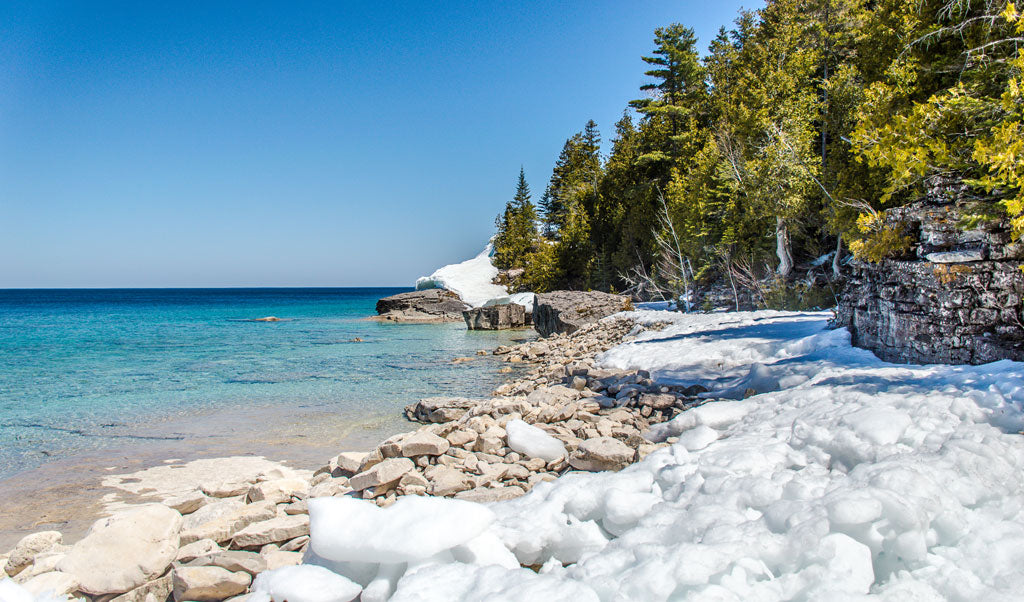
16. Bruce Trail
The Bruce Trail is Canada's oldest and longest marked hiking trail.
- Countries: Ontario, Canada
- Distance: 890 km (550 mi)
- Time to complete: 4 to 6 weeks
- Elevation change: Unknown
- Best time to visit: April to early November
First conceived in 1959, The Bruce Trail starts in Ontario, Canada just outside Niagara and runs over 500 miles to the end of Tobermory, Ontario. It travels through some of the most populated areas in the Provence, but that doesn't mean it's an urban walk. You’ll hike through quaint towns, traverse dense forests, stand at the edge of lakeside cliffs and marvel at pristine waterfalls.
The Bruce Trail is broken up into nine sections each of which has a subsidiary club. These clubs offer end-to-end hikes of their assigned segments. People who want to hike the entire trail in sections can join these individual guided, group hikes. The Bruce Trail Conservancy maintains the path and is the first place you should look for more information.
 CC BY-SA 4.0 | Wikimedia Commons (tiziana corsi)
South America
17. TransPanama Trail
Hike 700 miles across the length of Panama from Costa Rica to Columbia.
- Countries: Panama
- Distance: 1126km (700mi)
- Time to complete: 3 to 4 months
- Elevation change: Unknown
- Best time to visit: June to September
Connecting an existing network of hiking trails and remote roads, the TransPanama Trail covers the length of Panama from the border of Columbia to the border of Costa Rica. It traverses mountains, rainforests and the territories of some of Panama's indigenous people.
The western half of the trail opened in 2009 but funding dried up and the momentum to complete the trail lost its steam. In 2011, Panama resident Rick Morales decided to change all that and set out on the first ever thru-hike from Columbia to Costa Rica. Morales not only hiked the existing trail, but he also mapped the route for the eastern trail. You can read about Morales's first thru-hike on his website. A trail guide is also in the works.
 CC BY-SA 4.0 | Wikimedia Commons (Ciorraga)
18. Greater Patagonian Trail
The 1,300 mile Greater Patagonian Trail allows you to experience South America at its best.
- Countries: Argentina, Chile
- Distance: 1300 miles
- Time to complete: 2 months
- Elevation change: 58,900 m elevation gain, 59,200 m elevation loss
- Best time to visit: December to April
The Greater Patagonian Trail is the longest hiking trail in South America. First mapped in 2013 by Swiss explorer Jan Dudeck and Chilean hiker Meylin Ubilla, the GPT is an amalgam of unmarked hiking trails, horse trails, dirt roads, and rivers. The trail passes through the heart of the Andes into Southern Patagonia. Its route was chosen to reflect the beauty, culture and natural history of the area.
You can hike the entire distance or decide to pack raft down rivers, lakes, and fjords. Visit the GPT wikiexplora to learn more about this unique trail.
 CC BY 2.0 | Petr Meissner
Africa
19. Drakensberg Grand Traverse
Experience the wild of the South African mountains.
- Countries: South Africa
- Distance: Up to 240km (150mi) and two to three weeks
- Time to complete: 2 to 3 weeks
- Elevation change: 10,000m
- Best time to visit: September to December (spring) and March to June (fall)
The Drakensberg Grand Traverse (DGT) starts at Sentinel Car Park and finishes at the Bushman’s Neck Border Post, but it isn't a marked hiking trail like the AT. Instead of following a predefined path, you are required to pass through eight checkpoints, some of which are mountain peaks, if you want to claim you completed the DGT. You can choose your route to these checkpoints, but most people straight line them as much as possible.
The terrain is not technical, but the steep ascents and need for strong navigational skills can test even the most experienced hikers. It is an authentic wilderness experience with only a few towns or facilities along the way.
The best sources of information on the trail can be found at the Hiking South Africa website and online journals.
 CC BY-ND 2.0 | Pippa Dini
20. Sir Samuel And Lady Florence Baker Historical Trail
Follow in the footsteps of Sir Samuel Baker and his wife, Lady Florence.
- Countries: Uganda, Sudan
- Distance: 850km (500mi) and two to three months
- Time to complete: 2 to 3 weeks
- Elevation change: Unknown
- Best time to visit: June to August and December to February
The Sir Samuel and Lady Florence Baker Trail has been hailed as one of the best hiking trails in the world, but civil war in the Sudan region has made it impossible to hike this section of the trail. The path was designed to follow the travels of Sir Samuel and Lady Florence Baker who explored the area in the 1860s and 1870s.
The trail begins in the Sudanese village of Gondokoro, which is located near the Sudan capital of Juba. It travels south to Baker's view overlooking Lake Albert and finally onto Murchison Falls on the Nile River.
Because of conflict in Sudan, the northern part of the trail is closed and not safe for hiking. The Ugandan section of the trail is open and safe for hiking. Information on the Baker Trail is sparse, but the Baker Trail website has additional information on the trail.
 Photo by Rod Waddington
Oceania
21. Bibbulmun Track
The walking-only Bibbulmun Track traverses the most beautiful state parks and scenic locations in southwestern Australia.
- Countries: Western Australia
- Distance: 623 miles
- Time to complete: 6 to 8 weeks
- Elevation change: 18,485 m elevation gain
- Best time to visit: April to early November
The Bibbulmun Track starts outside Perth in the suburb of Kalamunda and travels to the coastal town of Albany. The trail can be broken down into 58 sections, each of which is a day hike or less. At the end of each section, there is a campsite with a shelter, pit toilet, and other amenities. Most of the trail passes through state forestlands, national parks, and other preserves. The track is well maintained, well traveled and well-marked with the yellow Waugal, a symbol for a dominant spirit of the native Noongar people.
The Bibbulmun Track website has all the details you need to know about Australia's long-distance trail.
 CC BY-SA 3.0 | Wikimedia Commons (lucysthings)
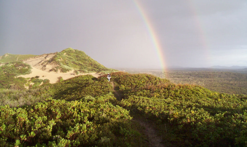
22. Te Araroa
- Countries: New Zealand
- Distance: 3,000km (1,900mi)
- Time to complete: 3 to 6 months
- Elevation change: Unknown
- Best time to visit: September to April
One of the newer long distance hiking paths, the Te Araroa trail officially opened in 2011. Maori for ‘Long Pathway,’ the Te Araroa lets you experience the best New Zealand has to offer. You walk through lush forests, follow country roads and tackle challenging scree while soaking in some of the most beautiful scenery in the world which includes sandy beaches, lush rainforests, active volcanoes, and glacial lakes.
There is an official guidebook, but you'll have to rely on GPS and your navigation skills as you follow the sometimes marked trail. There are no permits, and no fees are required but the Te Araroa Trust that oversees the path asks for a donation of the Te Araroa Trust requests a donation of $500 per person for those hiking the full trail, $250 for those walking on a single island only, and lesser amounts for section hikers.
The Te Araroa Trust website has all the information you need to hike the trail.
 CC BY-SA 4.0 | Michal Klajban

 650-Calorie Fuel